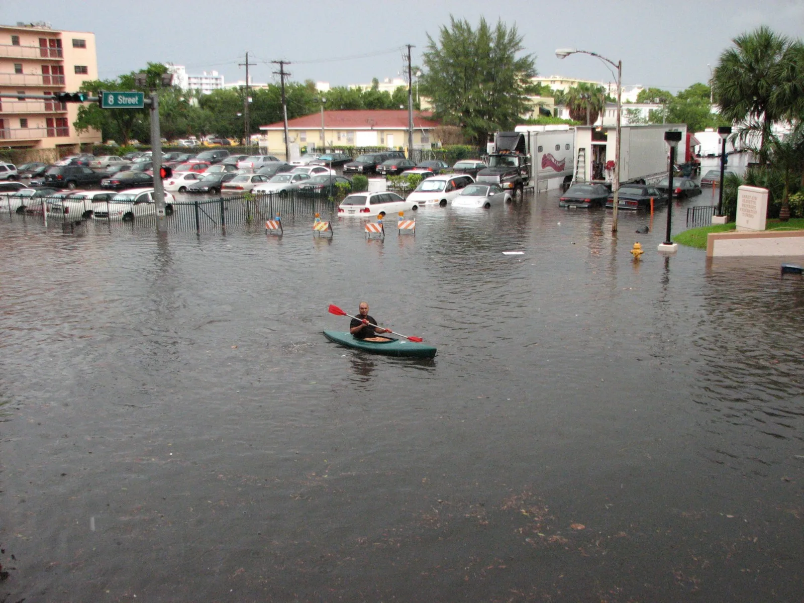
The coastal flood advisory now runs to 7 p.m. Tuesday; Tuesday's high tide is 4:05 p.m. The rain flood watch ended Monday evening. Daily readings since the Oct. 27 peak.
The king tide reached major flood stage at the Virginia Key tide gauge on Tuesday morning, the highest water at the gauge since Hurricane Irma in 2017. The National Weather Service in Miami has extended the coastal flood advisory that replaced its warning five times. It now runs until 7 p.m. Tuesday, Nov. 3. A separate flood watch for heavy rain ended at 7 p.m. Monday.
Updated Nov. 2, evening: The weather service extended the advisory to 7 p.m. Tuesday. The flood watch, extended to 7 p.m. Monday, has ended. This story now has Monday’s readings and Tuesday’s high tide times.
Updated Nov. 1, evening: The weather service extended the advisory to 7 p.m. Monday and issued a flood watch for 3 to 5 inches of rain. This story now has Sunday’s readings and Monday’s high tide time.
Updated Oct. 31, evening: The weather service extended the advisory again, to 7 p.m. Sunday. This story now has Saturday’s readings and Sunday’s high tide time.
Updated Oct. 31: The weather service extended the advisory through Saturday, Halloween. This story now has the readings for Thursday and Friday and Saturday’s high tide time.
Updated Oct. 28: The warning was extended through Wednesday and expired at 8 p.m. Wednesday. This story now has the readings for Monday to Wednesday and Thursday’s peak time. It was first published Sunday, Oct. 25.
What the weather service says now
The National Weather Service in Miami first issued the advisory at 7:54 p.m. Wednesday, Oct. 28, for coastal Miami-Dade and coastal Broward counties. Its latest statement, at 3:20 p.m. Monday, keeps it in force until 7 p.m. Tuesday for coastal Miami-Dade, Broward and Palm Beach counties. It expects “moderate coastal flooding,” with “flooding of lots, parks, and roads with only isolated road closures expected.”
The warning it replaced had been in force since 2 a.m. Monday. On Tuesday the weather service extended it by a day. That warning said “numerous roads may be closed” and that low-lying homes, businesses and some critical infrastructure “will be inundated.”
The high rip current risk for coastal Miami-Dade ended at 8 p.m. Wednesday. The weather service reissued it from 8 p.m. Friday. Its Monday statement keeps it in force through Tuesday evening. It said rip currents “can sweep even the best swimmers away from shore into deeper water.”
Heavy rain on top of the tide
The weather service also issued a flood watch at 12:49 p.m. Sunday for all of Miami-Dade, Broward and Palm Beach counties. On Monday it extended the watch to 7 p.m., and it then ended. Its last statement, at 6:21 p.m. Monday, said heavy rain “resulted in localized flash flooding on Sunday and earlier today.”
At Miami International Airport, about 10 miles west, the weather service recorded 1.57 inches of rain Sunday and a trace on Monday through 4 p.m.
When it was issued, the watch said:
- scattered spots along the east coast may get 3 to 5 inches of rain through Monday
- isolated spots may see 5 to 7 inches, and that rain may fall over a few hours
- the main impact would be street flooding and road closures
- impacts “could be greater than forecast if the heaviest rainfall occurs near the coast during times of high tide”
The weather service said uncertainty is high about exactly where the heaviest rain will fall.
How high the water got
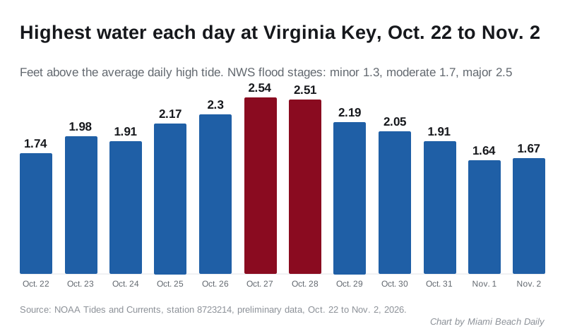
The tide gauge on Virginia Key, just south of Miami Beach, measured 2.54 feet above the average daily high tide at 10:18 a.m. Tuesday. NOAA had predicted 0.74 feet for that tide. On Wednesday the gauge peaked at 2.51 feet at 11:12 a.m., against a prediction of 0.70 feet.
The water then eased but stayed in moderate flood stage. Thursday’s peak was 2.19 feet at 12:06 p.m., and Friday’s was 2.05 feet just after midnight. Saturday’s highest was 1.91 feet at 1 a.m. The afternoon tide reached 1.73 feet at 2 p.m., still just inside moderate flood stage.
On Sunday the water peaked in minor flood stage, below the moderate level it reached every day from Oct. 22 to Oct. 31. The overnight tide peaked at 1.64 feet at 1:12 a.m., and the afternoon tide at 1.56 feet at 2:18 p.m.
Monday was similar. The overnight tide peaked at 1.67 feet at 2:24 a.m., just short of moderate flood stage, and the afternoon tide at 1.51 feet at 2:42 p.m.
Both readings passed the 2.5-foot major flood stage that the National Water Prediction Service sets for the gauge. Its other stages are:
- Minor: 1.3 feet
- Moderate: 1.7 feet
The figures are NOAA’s preliminary readings for station 8723214 and may still be revised.
NOAA’s monthly records for the gauge begin in 1994. Only two months show a higher top reading than Tuesday’s: September 2017, when Hurricane Irma passed, at 3.57 feet, and October 2005, when Hurricane Wilma struck, at 2.55 feet. Tuesday’s tide came with no hurricane. A strong northeast wind and the year’s highest tides did it.
| Day | Highest water measured | NOAA prediction for the day’s highest tide |
|---|---|---|
| Thursday, Oct. 22 | 1.74 feet at 6:42 p.m. | 0.31 feet |
| Friday, Oct. 23 | 1.98 feet at 7:12 a.m. | 0.41 feet |
| Saturday, Oct. 24 | 1.91 feet at 8:18 a.m. | 0.54 feet |
| Sunday, Oct. 25 | 2.17 feet at 8:54 a.m. | 0.65 feet |
| Monday, Oct. 26 | 2.30 feet at 9:42 p.m. | 0.72 feet |
| Tuesday, Oct. 27 | 2.54 feet at 10:18 a.m. | 0.74 feet |
| Wednesday, Oct. 28 | 2.51 feet at 11:12 a.m. | 0.70 feet |
| Thursday, Oct. 29 | 2.19 feet at 12:06 p.m. | 0.62 feet |
| Friday, Oct. 30 | 2.05 feet at 12:06 a.m. | 0.53 feet |
| Saturday, Oct. 31 | 1.91 feet at 1 a.m. | 0.44 feet |
| Sunday, Nov. 1 | 1.64 feet at 1:12 a.m. | 0.36 feet |
| Monday, Nov. 2 | 1.67 feet at 2:24 a.m. | 0.32 feet |
Every day from Oct. 22 to Oct. 31 reached moderate flood stage at the gauge. Sunday was the first day back below it, and Monday stayed below it.
Tuesday’s high tides
High tide at Virginia Key is predicted for 3:33 a.m. and 4:05 p.m. Tuesday, from NOAA’s tide predictions. Both are forecast at about 0.3 feet. That is the tide alone. On Monday afternoon the water still ran about 1.2 feet above the tables. Water can stay high for 1.5 to 2 hours on either side of each peak, the city says.
The city’s first king tide window ended Friday, Oct. 30. The next windows are Nov. 6-9 and Nov. 23-26.
Why the tides are higher than forecast
The tide tables cover the moon and the sun only. A strong northeast wind piled extra water against the coast in late October.
On Sunday, Oct. 25, the weather service issued a gale warning for Biscayne Bay and the nearby Atlantic waters through Tuesday. It forecast northeast winds of 20 to 25 knots, about 23 to 29 mph, with frequent gale-force gusts.
What the city says
The city had not posted a news release about the flooding on its newsroom by Wednesday evening. Its king tides page now gives the season’s first window as Oct. 22-30, two days earlier than the Oct. 24 start it listed earlier this month.
The city’s Parking Flood Relief Program lets registered residents on low streets park free in garages G1 (200 7th St.), G9 (1661 Pennsylvania Ave.) and G6 (400 W. 42nd St.) while a city flood notification is active. Registered users get the notice by email. We could not confirm which streets the city closed this week from a city notice.
What it means for you
- Move your car before Tuesday’s 4:05 p.m. peak if your street floods. The water can arrive by about 2 p.m., and rain near high tide makes it worse.
- Do not drive through standing water. The weather service said: “do not drive around barricades or through water of unknown depth.” Salt water damages cars; rinse the underside if you drove through it.
- Swim only near a lifeguard. The high rip current risk runs through Tuesday evening.
- Boaters: high water lowers bridge clearance.
- Road updates: text MBTraffic to 888777.
- Report flooding that blocks a street or damages property to the Public Works control room at 305-673-7625 or flooding@miamibeachfl.gov.
- Parking questions: the Parking Flood Relief line is 305-673-7505.
Our king tides guide has the November dates and peak times. For closures already planned, see our road construction and closures page. Waterfront owners can read about the city’s seawall grant program.
Have your say